“ A delightful trek experience for the Service provided by Adventure Heights for Hemkund sahib and Valley of Flowers. Superb coordination on-route, vehicles, accomodation at respective base camps, ”

Bagini Glacier Trek
The Bagini Glacier Trek is a thrilling trek and lifetime experience through the heart of the Garhwal Himalayas, offering trekkers a perfect blend of adventure, stunning landscapes, cultural immersion and a deep connection with nature. Whether you are a seasoned trekker or someone looking to push your limits, this trek promises to leave you with unforgettable memories of the majestic Himalayas.
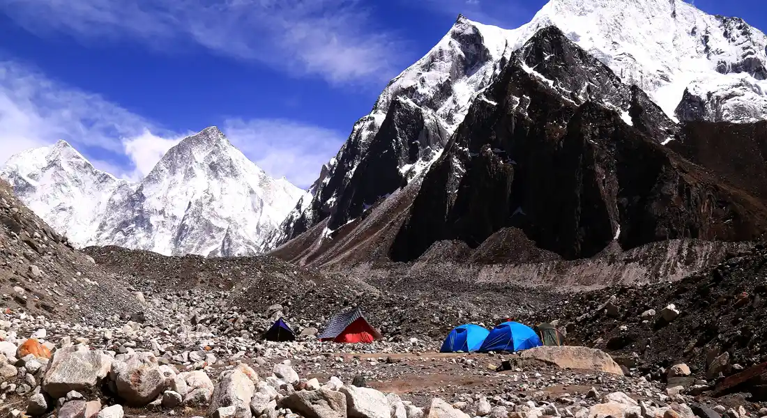
Bagini Glacier situated at an elevation of approximately 4515 M, the trek takes you through remote villages (Ruin & Dronagiri), dense forests, and awe-inspiring mountain views.
The highlight of the trek is the Bagini Glacier, a pristine ice mass surrounded by amphitheatre of snow-capped mountains like Rishi Pahar (6992 M), Safminal (Satminal – 6911 M), Changbang (6864 M), Kalanka (6931 M), Trishul (7120 M) & Hardeaol (7151 M), truly a sight to behold.
The trek provides panoramic views of some of the most majestic peaks of the Garhwal Himalayas. As you ascend, the vistas become more dramatic, with the mighty Dunagiri (7066 M), Hathi Parvat (6727 M) and Ghori Parvat (6719 M) making appearances along the way.
The best time to do this trek is May to June and September to October. It is a moderate to challenging trek, suitable for seasoned trekkers or those with prior trekking experience. The high altitude and steep ascents require good physical fitness and proper acclimatization.
The trek begins at Jumma, which is accessible by road from Joshimath and lies on the route to Niti Pass, a village near the Indo-Tibetan border. From Jumma, you ascend a few kilometers to reach Ruin, a small, picturesque village.
The campsite is located just outside the village. Take some time to relax and properly acclimatize. Start early the next day with a packed lunch, and enjoy trekking through thick forests. The last few kilometers involve a challenging ascent that leads you to Dronagiri Village. Find a suitable campsite with a nearby water source for the night. Try interact with village people to know their religious and cultural landscape of the region.
From Dronagiri, the trail descends to a river, followed by a steep ascent towards Laungatoli just after crossing the river. Settle in for a scenic camping experience at Laungatoli, near the river. In the morning, enjoy and admire the breath-taking sight of Hathi-Gauri Parvat bathed in golden sunlight. Next comes the most challenging part of the trek, from Laungatoli to Upper Bagini Base Camp.
By this point, you've already gained significant altitude, evident in the absence of the tree line. The first few kilometers involve traversing moraine, followed by a stretch of boulders leading to the campsite. The next day, from Upper Bagini Base Camp, trek along the glacier to visit Rishikund, where you'll be rewarded with panoramic views of the majestic Changbang, Kalanka, Trishul, and Hardeol mountain peaks. After taking in the stunning scenery, return to the base camp to prepare for your journey back to Laungatoli.
The next day, embark on a long but easy descent to Ruin, where you'll camp for the night. Enjoy a relaxed morning in Ruin before descending to Jumma and driving back to Joshimath.
Trekking Advisory
- Walk with ease, do not hurry (you are not into a race). Walking stick helps.
- Be in the group, don’t be left alone or walk alone.
- Remain Hydrated, take ample water.
- Use Head Gear (Cap/ Hat to protect you from Sun).
- Use dark glasses to protect your eyes (In snow it is must).
- Ensure safety before taking a selfie.
Ecological Advisory
- Keep Himalaya Clean.
- Do not litter around.
- Keep a Garbage bag along with you, bring it back to the Base to dispose it off properly.


